website language
EN   NL   NO   ES   FR

Geographer & Geoscientist
info@rubenlelivelt.nl


  Project Map in Full Screen        

About myself

I am Ruben Lelivelt and I worked from 2007 to 2012 as an independant physical geographer in archaeology. Although I am no longer active as an independent consultant, I would like to keep in touch with colleagues. Below, you find an overview of some of my projects .

After having finished my studies in physical geography at Utrecht University (1996-2001) I was employed at BOOR (City Archaeology Rotterdam) as a physical geographer. Subsequently, I started working as a physical geographer in archaeology and quaternary geology on a freelance basis. Alongside my work I kept my knowledge concerning archaeology and earth sciences updated by studying for an MSc in geoarchaeology at the VU University in Amsterdam (2007-2012). Geoarchaeologist use techniques from earth sciences to solve archaeological problems.

Since 2012, I live and work in Stavanger, Norway. The last few years I worked as a GIS consultant for Geodata, the Norwegian distributor of ESRI's GIS software. As such I was contracted by Shell Norway.

Projects in Norway

2015 - 2013 ~ Exploration & Production ›› A/S Norske Shell
  • Shell Upstream Europe: geomatics team in Aberdeen (UK), Assen (NL) and Stavanger (NO)
  • XYZ data: process and visualize bathymetry data (DTM)
  • Norwegian Continental Shelf: business users in exploration, development and support services
  • Support exploration on regional studies: numbered concession rounds (frontier areas) and concession rounds in mature areas (APA: Awards in Predefined Areas)

2015 - 2013 ~ (Sub)surface Geodesy ›› A/S Norske Shell
  • Ensure geodetic integrity (use correct transformations, map projections, geodetic datum, etc)
  • Quality control spatial data on 2D and 3D seismic navigation
  • Improve well data loading by applying LEAN principles
  • Improve workflows (automation) of loading and quality control of spatial well data in well database (CDS)
  • Participant in a Terms of Reference Group (Shell), a global initiative to standardise loading of geodetic well data
  • Wells workshop at Shell Aberdeen (UK)

2015 - 2013 ~ Mapping and GIS ›› A/S Norske Shell
  • Manage and update GIS layers
  • Maintain metadata to comply with Shell business standards
  • Support on scripting (FME, python)

2012 ~ Excavation Hove - Sørbø ›› Archaeological Museum Stavanger (Stavanger University)
  • Ca. 65 m long 'langhus' with monumental front and stairs
  • The 'langhus' probably belonged to a chieftain
  • Toponym 'Hove': 'hov' means significant place of worship/central building
  • This house lay-out dates from the period 400 - 550 AD (Migration Period)
  • Furthermore, dozens of house lay-outs dating from Bronze Age to Iron Age
  • Area with damaged gravemounds
  • Various cremation graves, including one containing a golden ring
  • Newspaper article: Aftenposten
  • Newspaper article: Stavanger Aftenblad

Projects in the Netherlands

2011 ~ Vlaardingen Stadshart ›› VLAK (Vlaardingen municipality)
  • Archaeological and geological research in the centre of Vlaardingen
  • Relation between environment and preservation in situ of archaeological material
  • Development of a 3D GIS model of subsurface Vlaardingen
  • Archaeological research in cooperation with IGBA, ArcheoMedia en MVH Consult

2011 ~ Geoheritage 'Meester van der Heijden groeve' ›› Staatsbosbeheer
  • Former sand-pit Meester van der Heijden groeve, Zeeuws-Vlaanderen
  • Important geoheritage, managed by Staatsbosbeheer
  • Outcropping Pliocene sands of more than 2.5 million years old
  • Geological research in cooperation with GEO-LOGICAL en VU University
  • Archaeological research in cooperation with BAAC BV
  • Section descriptions focusing on sediment characteristics, molluscs and fossil burrows
  • Information panel Staatsbosbeheer in cooperation with artist Pieter Jouke

2011 - 2003 ~ Archaeological prospection projects in Rotterdam area ›› BOOR (Gemeentewerken Rotterdam)
  • Description manuel and mechanical sediment cores
  • Experience with excavations and test pits
  • Urban area (i.e. Rotterdam, Schiedam)
  • Rural area (i.e. Brielle en Westvoorne)
  • Holocene marine, perimarine and fluvial deposits
  • Stone age - Modern history
  • Total Station and ArcGIS

2011 - 2009 ~ Quick scan geoheritage ›› Staatsbosbeheer
  • Utrecht, Zuid-Holland, Noord-Brabant and Zeeland
  • Geoheritage database
  • Inventory with (digital) maps
  • In cooperation with GEO-LOGICAL and Buro Maerlant
  • ArcGIS

2009 - 2008 ~ Archaeological prospection Valkenburg Airfield (Leiden) ›› Leiden University & Archol BV
  • Sediment cores and test pits
  • Development of coastal area
  • Holocene marine, perimarine and fluvial deposits
  • Early prehistory - Middle ages
  • Educating archeology students: sediment description

Projects in the Mediterranean

2012 - 2007 Geoarchaeology ›› VU University

Landscape reconstruction near Taranto, Apulia, southern Italy ›› VU Amsterdam
  •   Taras River, Italy
  • Title: Landscape evolution during the Greek period in the Taras floodplain, Apulia, Italy. A literature overview and landscape reconstruction, using lithological and (micro)faunal criteria, GIS and present environmental conditions
  • Holocene palaeolandscape research in the coastal marshlands near l'Amastuola
  • In cooperation with the Royal Netherlands Institute Rome (KNIR)
  • Focus on landscape development during the foundation of the colony of Taras (modern Taranto) in 706 BC by Greek colonists
  • Analysing mollusc records in peat and clay deposits in cooperation with Naturalis
  • Sediment cores
  • Assessing peat quality and preservation level of pollen
  • Determining pH and EC levels
  • GIS analysis

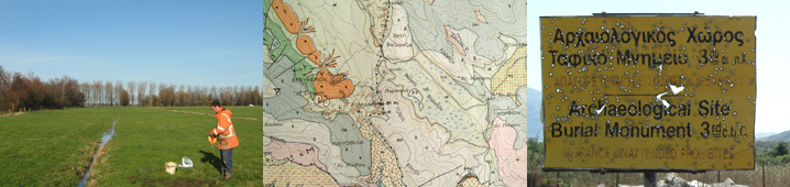
Landscape Reconstruction, Kalodiki Fen, Thesprotia, NW Greece ›› VU Amsterdam
  •   Kalodiki Fen, Greece
  • Title: Lithological analysis of Holocene lake sediments in the Kalodiki Fen, Thesprotia, Western Greece. Issues and possibilities of using mediterranean wetland data in landscape archaeology
  • Interdisciplinary archaeological research: The Thesprotia Expedition
  • In cooperation with Finnish Institute at Athens: FIA
  • Holocene landscape reconstruction in lacustrine environment
  • Sediment cores
  • ArcGIS

2001 ~ 1996 MSc Physical Geography ›› Utrecht University

Hydrological research La Peyne, Southern France ›› Utrecht University
  •   La Peyne, France
  • Title: Het effect van verschillende bodemparameters op de infiltratie in het Peyne-stroomgebied, Zuid Frankrijk. Toepassen van het fysisch deterministisch infiltratiemodel van Philip en het opstellen van transferfuncties van de verzadigde doorlatendheid voor kalkrijke bodems
  • English translation: The Effect of Different Soil Parameters on the Infiltration in the Peyne Catchment, Southern France. Application of the Physical Deterministic Infiltration Model by Philips and the Design of Transfer Funtions of the Saturated Hydraulic Conductivity for Calcareaous Soils
  • Satellite Based Desertification Monitoring in the Mediterranean Basin (DeMon)
  • Analysing Data with multivariate statistics
  • Performing various field and laboratory tests
  • Soil and water problems of arid zones in the mediterranean

Hydrological research Talkjounte, High Atlas, Morocco ›› Wageningen University
  •   Talkjounte, Morocco
  • Title: The effect of a traditional irrigation method in the Western- Atlas Mountains of Morocco on the water balance and crop of a field. Application of a field scale irrigation model on a olive-tree field in the watershed of Talkjounte
  • Traditional irrigation
  • Water Harvesting Impact Assessment (WAHIA)
  • In close cooperation with Ibn Zohr University, Agadir, Morocco
  • Working independently in developing country
  • Integrating socio-economic data in a hydrological model
  • Modelling in EXCEL
  • Traditional irrigation of arid zones in the Mediterranean